


Abstract
Species identification and global positioning system coordinates of infestations of cattle fever ticks, Rhipicephalus (Boophilus) annulatus (Say) and Rhipicephalus (Boophilus) microplus (Canestrini), were determined for 790 specimens submitted to the National Veterinary Services Laboratory between 1 October 1999 and 30 September 2010. Cattle fever tick specimens obtained by personnel of the United States Department of Agriculture–Animal and Plant Health Inspection Service–Cattle Fever Tick Eradication Program from infested cattle and wildlife along the Texas/Mexico border were submitted for identification, as required by the program. A geographic information system database was developed that incorporates location, collection, and infestation records. Submitted ticks came from 11 Texas counties and were comprised of 19.5% R. (B.) annulatus and 80.5% R. (B.) microplus. Maps produced from this study locate and define the parapatric boundary between R. (B.) annulatus and R. (B.) microplus.
In recent years, cattle fever ticks, Rhipicephalus (Boophilus) annulatus (Say) and Rhipicephalus (Boophilus) microplus (Canestrini), have re-emerged as a serious threat to the United States livestock industry. Cattle fever ticks transmit bovine babesiosis (Texas fever), a disease that can be fatal in susceptible animals if left untreated (Smith and Kilborne 1893). In 2004, the number of cattle fever tick infestations recorded within the permanent quarantine zone and outside of it in the region known as the free area began to increase dramatically. Factors that appear to influence the increase of infestations outside the permanent quarantine zone include close proximity to infestations of both tick species across the border in Mexico, the large numbers of cattle being imported from Mexico and pastured in the free area, and the increase in density of white-tailed deer in southern Texas (Pound et al. 2010).
Anecdotal evidence gathered by personnel of the Cattle Fever Tick Eradication Program (CFTEP) suggests the presence of a boundary line separating R. (B.) annulatus from R. (B.) microplus infestations within the United States near Laredo, Texas (E. Bowers, Director of Field Operations, CFTEP, personal communication). Graham and Price (1966) noted a similar boundary between R. (B.) annulatus and R. (B.) microplus specimens collected from northern Mexico. Estrada-Peña and Venzal (2006) used remote sensing to map habitat suitability for R. (B.) annulatus and R. (B.) microplus in parts of Texas and northeastern Mexico and compared results with tick outbreaks from 1994 to 2004. The current study develops and queries a geographic database that incorporates collection records and infestation details gathered from recent infestations in south Texas to produce a distribution map that provides definitive evidence of geographical division and a parapatric boundary between infestations of the two species.
Materials and Methods
Identification records were acquired for tick specimens submitted to the United States Department of Agriculture, National Veterinary Services Laboratories (NVSL, Ames, IA), as part of the United States Department of Agriculture, Animal and Plant Health Inspection Service (APHIS), Veterinary Services, CFTEP from 1 October 1999 to 30 September 2010. Personnel of the CFTEP, headquartered in Laredo, Texas, routinely submit samples of cattle fever ticks from infested cattle, horses, white-tailed deer, and exotic ungulates, to NVSL for official identification. An animal is considered infested when even a single cattle fever tick of any life stage is physically detected either visually or by touch during inspection, also known as “scratching.”
Data for infestations reported by CFTEP were compiled into a database using Microsoft Access and collated with NVSL identification reports using owner, county, collector, host species, and/or collection date for cattle fever ticks identified to species by NVSL staff. A geographic information system database (GIS) was developed using ArcMap, version 10.0 (ESRI, Redlands, CA), and verified data were compiled into a geodatabase with feature classes for the two species. Shapefiles of digitized quarantined counties and the CFTEP-regulated permanent quarantine zone (also referred to as the systematic area or buffer zone) were overlaid on World Street Map (ESRI 2009). The combined database was used to produce county-level maps of R. (B.) microplus and R. (B.) annulatus infestations. Pasture gate locations for verified premises were identified using a series of colored dots. Georeferencing of infested premises was not a common practice before 1 October 1999; therefore, tick submissions before this date were not included.
Voucher specimens for collection records discussed in this report are archived in the NVSL Parasitology Reference Collection (Ames, IA). Telephone reports of infestations are retained in the CFTEP District Office (Laredo, TX).
Results
Between 1 October 1999 and 30 September 2010, 846 tick specimens from cattle fever tick infestations were submitted to NVSL by the CFTEP for identification to species. Of these, 790 were identified as R. (B.) microplus or R. (B.) annulatus and were collated with infestation data from CFTEP telephone reports. Of the remaining 56, 38 were larvae or nymphs that were not identified to species and 18 could not be matched with NVSL identification reports. Only the 790 specimens that were both identified to species and could be matched with infestation data were included in geographic database of tick infestations (Fig. 1). The total numbers of tick infestations by county in south Texas are summarized in Table 1. Verified specimens were reported from premises in 11 counties in south Texas, including all eight counties wherein lie portions of the permanent quarantine zone. The permanent quarantine zone extends ≈885 km from Lake Amistad near Del Rio, Texas, to the Gulf Coast near Boca Chica, Texas. Although not evenly distributed, tick infestations have been recorded throughout this range.
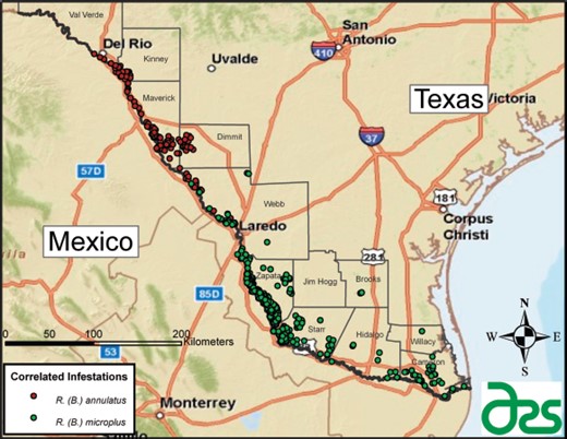
Verified infestations of R. (B.) annulatus and R. (B.) microplus in south Texas from 1 October 1999 to 30 September 2010. (Online figure in color.)
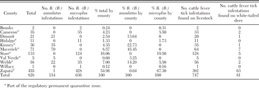
R. (B.) microplus and R. (B.) annulatus infestations by county, October 1999–29 July 2010
R. (B.) microplus and R. (B.) annulatus infestations by county, October 1999–29 July 2010
A predominance of R. (B.) annulatus infestations was recorded in Maverick and Kinney Counties, and most of the R. (B.) microplus infestations were recorded in Starr and Zapata Counties. Webb County was the only county with appreciable infestations of both species (Fig. 2). Infestations were recorded from cattle and horses in all 11 counties and from white-tailed deer and other wild ungulates in seven counties (Table 1). Zapata County had the largest numbers of infestations recorded from all host types.
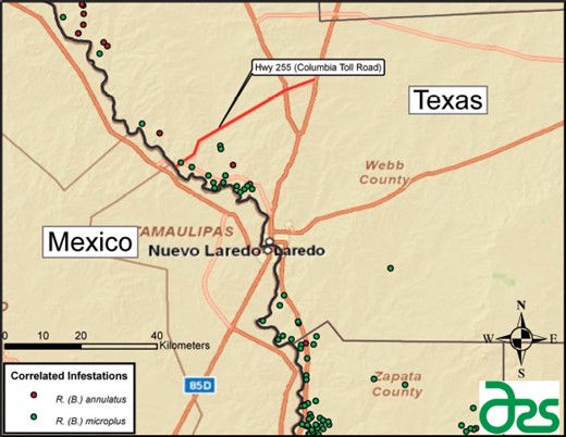
Verified infestations of R. (B.) annulatus and R. (B.) microplus in Webb County, Texas, 1 October 1999 to 30 September 2010. (Online figure in color.)
Discussion
For decades, anecdotal evidence has suggested a southwest to northeast projecting line separating infestations of R. (B.) annulatus from R. (B.) microplus. Based on many years of working with cattle fever ticks and monitoring infestations in south Texas, CFTEP personnel have hypothesized that a line approximating separation of the two species was located near Laredo, Texas. Through construction of a GIS database that spatially identifies verified infestations of R. (B.) annulatus from R. (B.) microplus over the 11 years from 1999 to 2010, it was determined that a boundary line does exist and that it is located north of Laredo near Highway 255 (Columbia Toll Road), which runs east to west (Fig. 2). Within Webb County, infestations of R. (B.) annulatus are found north of Highway 255 and infestations of R. (B.) microplus are found south of Highway 255. Although a few outliers were found outside of this boundary, they appear to have been caused by the unauthorized movement of cattle from other locations. Interestingly, our findings mirror a similar boundary between these species that was documented by Graham and Price (1966) in northern Mexico. They attributed this division to “hybridization, genetic instability, environmental effects, or interactions of these factors” that may constitute a parapatric boundary. Later work reported that interspecific crosses of R. (B.) annulatus and R. (B.) microplus produce sterile hybrid males that have absent or vestigial testes and hybrid females that produce sterile male progeny (Graham et al. 1972, Thompson et al. 1981, Davey et al. 1983). This suggests that in both Mexico and southern Texas, the two species are reproductively isolated because of hybrid sterility.
Webb County was the only county in south Texas with appreciable numbers of both R. (B.) annulatus and R. (B.) microplus. Although geographic coordinates of infestations were not available before 1 October 1999, cursory observations of infestations in Webb County from 13 January 1976 to 30 September 1999 found 57 infestations that reflect the same distribution trend observed between 1999 and 2010. Approximately 46 R. (B.) annulatus infestations were recorded north and 10 R. (B.) microplus infestations were recorded south of Highway 255 during this time period.
The clumped distribution of tick infestations in the free area resulted from additional surveillance being done surrounding initial infestations. When infestations are detected, pastures adjacent to the original infestation are also inspected, and all pastures with a circumferential area extending outward a specified distance, usually of 1–5 miles, are also inspected. This often leads to discovery of multiple adjacent infestations that appear as clumps on the larger infestation map. Surveillance is increased in an outward pattern around the original infestation until no additional infestations are found. It is important to note that other large expanses of land in the free area are seemingly without infestations; however, this does not necessarily indicate an absence of ticks, but more likely a lack of surveillance. Large areas surrounding cities near the Rio Grande, including Laredo, McAllen, Harlingen, and Brownsville, appear void of tick infestations primarily because of a paucity of pasturage that would support cattle or ungulate wildlife.
Dots on the infestation distribution map represent gate coordinates for infested pastures and not sizes of infested pastures. The average acreage of pastures along the Rio Grande in counties north of Laredo is considerably greater than for those from Laredo south to Brownsville. Individual pastures in the northern counties have, on average, longer river frontages than southern pastures, which are narrow elongated rectangles with long axes extending perpendicularly away from the river and proportionally much narrower widths oriented parallel to the water frontage. This design for the division of southern lands into pastures was intended to maximize the number of these smaller fenced premises having river access as a source of water for livestock, whereas the northern premises were designed to permit pastured livestock in these much larger premises greater access to water along the river. The ease of access to the river and the elongated shape of pastures in the southern part of the quarantine zone may promote the spread of R. (B). microplus, particularly in Zapata County (Pound et al. 2010). As water levels rise and fall, cattle, horses, and wild ungulates are easily able to cross the river between Mexico and the United States, carrying ticks back and forth across the border. During times of drought, fences leading to the water in these long narrow pastures may not even reach the water's edge, thus allowing the animals to have unrestricted access to multiple premises. The elongate shape of the pastures in these southern areas also allows animals that have crossed the river deeper penetration into the quarantine zone before encountering an impediment to further movement. The average sizes of infested pastures in Zapata and Starr Counties are 132 and 157 ha, respectively, yet the typical home range of a white-tailed buck in south Texas is considerably larger (≈249–672 ha). This implies that a single deer may routinely traverse among multiple low-fenced pastures and potentially spread ticks throughout its range (Hellickson et al. 2008, Webb et al. 2010, Pound et al. 2010).
As new cattle fever tick control techniques become available, it will be important to consider their potential impact on the distribution of both species of ticks. If the boundary between R. (B.) annulatus and R. (B.) microplus is indeed caused by interspecific mating incompatibility, then reducing or eliminating populations of R. (B.) annulatus with a species-specific control technique may allow infestations of R. (B.) microplus to expand further into northern regions.
The map showing distribution of cattle fever tick infestations presented in this work will provide a valuable basis for future studies addressing cattle fever tick geographic distribution and population dynamics in northeastern Mexico and south Texas. In addition, the maps better define the parapatric boundary between R. (B.) annulatus and R. (B.) microplus infestations. This GIS database is an important tool for identifying and analyzing cattle fever tick species infestation ranges, as well as in predicting likely areas in which future outbreaks might occur.
Acknowledgments
We thank the APHIS–CFTEP personnel, including the tick inspectors and supervisors, for their assistance with tick collection, and H. Joel Hutcheson and other APHIS–NVSL staff for assistance with tick identifications.
References Cited
